Go figure... We had all of our redlining around Rowe finished, and then they go and add two new required trails! Trails, by the way, which are also not on the current official Belknap hiking map. So they take a bit more research and explorative spirit.
Thankfully, many other fellow redliners have shared notes on the Belknap hiking group, and one of the tracks is even on alltrails. (The latter fact I had forgotten until we were approximately halfway up the trail. LOL) Still, there are several cross country ski trails and other paths crossing the official hiking trails, so it can be easy to get mixed up out there without adequate trail markings or signage if you don't pay attention. You probably wouldn't get hopelessly lost, and you might even find an enjoyable alternate route, but obviously when you're redlining, you try to stay on every inch of the required trail as possible. [In case you aren't familiar with "redlining" it's when you hike typically all of the official trails in a certain area or mountain range, rather than just "peak bagging" where you summit a set of mountains by any single route of your choice.]
Our day began with knowing we were hiking, but not knowing where, when, or for how long. Hummingbird & I threw around several options without definitively settling on anything. Eventually we came up with a loose plan and decided to just go with the flow. We'd leave whenever we were ready, grab a trail or two that we needed, and mostly just hike until we felt like turning around. If we hit an unappealing trail, we'd simply go find a different one. More than half of this "plan" was formed as we drove in the direction of where we'd be hiking! Ah, the commitment-resistant genes were strong today! But we just called it adventurous and "spiritual" and flowing in the present moment. 😉
I wasn't originally going to label this hike as overambitious. It was ambitious for sure, but it didn't quite seem overly so at the time. I fully believe that part of the perceived difficulty level (which I'd call moderate) had to do with how much I was carrying. Or should I say, not carrying? You may remember early this month I did Avery & Anna wearing the big pack, and it hit me hard. Yet today's hike was longer with more elevation gain, and I felt like I handled it better. Perhaps my fitness is improving some, but the major factor was surely that I only carried my mini pack on Rowe. It had just enough space for all I might need on this fine day, and Hummingbird was kind enough to carry an extra water for me. It definitely worked well, as I wasn't suffering debilitating pain or energy crashes while hiking; only the expected rubberiness and "feel the burn" sensations, with just a little tightness near the end of the hike. I figured my usual oils & arnica would take care of that, and I might even be able to hike again the next day. However, two days later I am still feeling more sore than I should after a reasonable hike, so I guess I may have overdone it a little after all. No regrets! But useful to know for planning future hikes.
 |
I found a pretty rock.
|
We started by finding the secondary parking area at Gunstock, which was a bit of an adventure in itself, down a road in rather poor condition. Hummingbird commented that she would have driven her new SUV rather than take my Camry if we knew the road would be that bad. But it was entirely manageable, and had very little traffic, which I was particularly grateful for at the times I had to carefully veer onto the wrong side of the road to avoid massive holes!
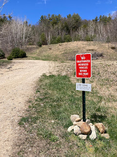
Once we parked, the scavenger hunt began. It certainly felt like that's what it was, in a fun way. Our first clue was posted right at the road gate, pointing us to hiking trails ahead on the right. We could spot a sign in the distance that we recognized from photos another hiker had helpfully shared, so we knew where step one and two were.
From there we continued forward, not sure yet where the trail actually was. But soon enough we found another small sign directing hikers to a very natural looking grassy path that forked, with Rowe's Revenge (our goal) going right, and another trail we didn't need heading left. I think I read nice things about that trail too, so perhaps we'll return to check it out some time. But for now, our focus was redlining.
 |
Step one...
|
 |
Step two...
|
 |
Step three...
|
 |
The beginning was reminiscent of walking through a vineyard.
|
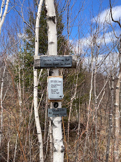
Rowe's Revenge was a nice trail; quite enjoyable. Overall the terrain was decent and in good condition, with a mix of gentle hiking and enough uphill to get your blood pumping. It's not blazed, but there are markers posted at most junctions, though the scavenger hunt continued with some of these, as a few were not super obvious unless you searched for them.
 |
Tiny white sign on a white birch... uh, yeah, maybe not the best idea. LOL
|
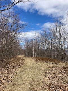 |
Still a very pleasant trail!
|
About a half hour in, we came to a spur with a little sign that simply said "view." Of course we had to detour from our redlining to explore it. After all, we may have had trail goals, but our primary goal was to just enjoy a fun hike. So off along the spur we went, and what a worthy detour it was!
We came upon a cement pad with a rustic bench and a cool circle of stones that kinda looked like a crystal grid, all overlooking a lovely view. It was definitely a surprising and unique sight! (The landing, I mean, not the view; those are plentiful in the Belks. 😉) Signage revealed that this used to be the site of a hut, back when Rowe was a downhill ski area. Neat! The stone circle turned out to be a "compass" that also noted the elevation, so that all made it even more cool. There was also a rock along the edge of the platform that suggested this might be a good place to view the sunrise. So later this year Hummingbird & I may very well return to check it out! 😁 The panoramic view overlooked Lake Winnipesaukee to the east (so certainly I can see it being a great sunrise spot) along with the ever present Ossipee Mts, and panned south to peek at another nearby range, which judging by distance I'm guessing might be the Moose Mts, but I'm terrible at ID'ing even local peaks, so don't take my word for it. Further off mountains spread out between the ranges, and the blue sky & scattered clouds were a beautiful finishing touch.
 |
A view spur is calling!
|
 |
Welcome to Alpine Ridge!
|
 |
I did not try the QR codes, but that's a cool bonus.
|
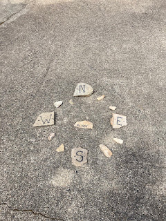 |
North, South, East, West - Belknap hiking is the best! 😎
|
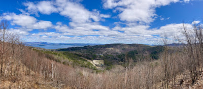 |
The view is from a lower elevation than the summits, but still plenty to see!
|
 |
Looks like an invitation! 😉
|
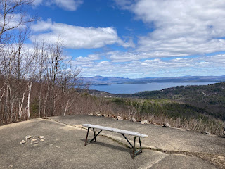 |
Definitely worth a second look.
|
 |
| I can see my car from here! 😄 |
 |
The next breadcrumb...
|
Once we were done admiring our latest discovery and discussing future visits, we plotted our next step. The spur trail appeared to continue, so we decided to follow it just to see where it went. It quickly came to a junction of different trails, and we looked around, unsure of where to go. Soon I spotted another clue in our scavenger hunt. Another small "sign" - a rock pointing in the direction to loop back to Rowe's Revenge. We didn't want to go too far out of the way, so we took it. Once back on our original trail, we backtracked to clean up the piece we missed taking the spur loop, just to be thorough redliners, then made a 180 to continue hiking towards the summit.
Rowe's Revenge eventually ends on the gravel road leading to the peak, which is officially part of Ridge Trail, aka BRT. Hawk & I finished our Belknap 12 patch on that boring slog of a road on a sweltering summer day back in 2019. We hit the unattractive radio tower and tree covered summit (which wasn't even well marked then), and immediately turned around to escape the heat, not realizing at the time that there was a gorgeous view just a smidge further around the corner. It was a rather anticlimactic way to earn a hiking patch, and quite miserable. Thankfully, today was much better weather for hiking, and we only needed to be on the road for a short time before summiting. (Honestly, the road really isn't awful, it's just that nearly any other trail up Rowe is much nicer.) And of course Hummingbird and I knew where to find the views from there.
At the summit we found the trail sign for the new Road Bypass trail, which was the other piece of redlining we needed, and our intended way down. We made note of it, and continued on to enjoy the view. This was about 20 minutes after hitting the Alpine Ridge overlook. From Rowe we evaluated our energy (i.e. how much more my body could handle) and decided to continue on towards Gunstock. Because why not? We didn't want to stop yet, and the elevation gain between summits should not be as much as from base. Plus there were other ways down from there if we didn't feel like completely reversing course. So I figured I had at least one more peak in me. We toyed with the idea of potentially going all the way to Belknap as well (or should I say Hummingbird threw it out there), but hey, one mountain at a time! (Whew, that definitely would have been overambitious! 😂) We also didn't set the strict goal of actually making it to any summit, although once we start in that direction, we both generally want to finish. But as per our original primary goal, we simply said we'd hike on until we felt like turning around.
So of course we made it to Gunstock. LOL We followed the Ridge Trail, which I'd forgotten how nice it is. There is an enjoyable mix of terrain, including some lovely "spongecake" (my term for a springy pine needle trail), as much as there was a mix of sights, ranging from blooming flowers to leftover snow on the ski trails!
 |
BRT from Rowe
|
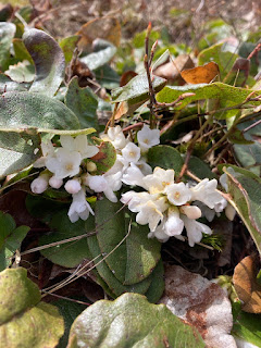 |
April showers brought Mayflowers!
|
 |
And here we have the remnants of winter.
|
At some point along the ridge, we came to another view spur, which although we'd checked out during previous redlining, we obviously wanted to revisit. This one pops you out onto one of those ski trails; I presume Flintlock, judging by these awesome maps. From a distance, I considered making snow angels when we got out there. I'd warmed up so much on the ascent that I was at least half serious about it, but once closer we could see how dirty the snow was, so... yeah, I skipped that idea.
The view from Flintlock was as pretty as we remembered, and the snow made for an interesting contrast to the rest of the morning's experiences. Since we had hiked all of the trails in this particular area, and we were right there, we decided we might as well just go straight up the ski trail the rest of the way to the top.
Now, I've heard Hawk tell stories more than once of how he learned that hiking up a ski trail is often the worst route you can take. It's often the shortest way up, but also typically the steepest. Also, not usually being established and maintained hiking routes, they can be very rough. After all, they primarily only get used when covered in multiple feet of snow. During the off season you might find they're covered in difficult rocks, or overgrown with brambles, or have other less than ideal conditions. So I was aware that hiking up Flintlock was not necessarily the greatest idea, but what the heck, it was something different and we were out for an adventure. And it really didn't look all that bad.
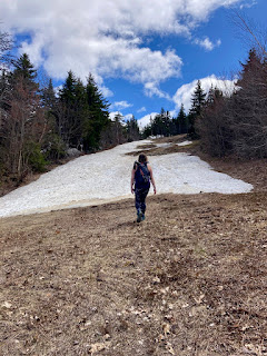 |
| Hummingbird looking like a hiking ninja with her poles strapped on her back. |
 |
In the home stretch, at last.
|
 |
See that peak down there with the tower? That's Rowe. Crazy how far away it looks, and to think we just hiked from there! And that we still have to go back!
|
Well, the ski trail didn't suck. But it definitely wasn't easy, and we probably wouldn't do it again. Still, we made it to the summit lodge, and enjoyed a well earned respite on the deck. During our hike we had run into a couple men, I presume father and son, who were aiming to hike the entire 12+ mile BRT. (We're also pretty sure we recognized the dad from somewhere; most likely the Belknap hiking group on FB!) They had passed us shortly after leaving Rowe, however we somehow managed to beat them to Gunstock, apparently by taking Flintlock up. So we caught them by surprise when they summited and joined us on the deck.
 |
Pano from the Gunstock summit lodge.
|
I called it enough of a hike from there. While I didn't feel the need to bail out directly from Gunstock, I knew I only had enough left in me to go back to Rowe and hit the Bypass trail. And so we turned back, this time taking the Ridge Trail all the way. Once on Flintlock was enough. 😉 I think I'll stick to hitting that trail on skis.
Wrapping around the back side of the mountain, we encountered a colder wind. It had been pretty breezy on the deck too, but this side felt even a bit colder. Presumably the temperature difference was at least partly due to air flow off the nearby snow. En route, we continued to fluctuate between being cold and warm. Springtime in New England summed up right there! LOL I hiked jacketless the entire way, but I did eventually need to pull my gloves out.
Conditions leveled out when we reached Rowe again, and we found our way down the Road Bypass trail. While Rowe's Revenge was unblazed but fairly well signed, the Bypass was well blazed, but had less definitive signage. The marker at the summit clearly pointed to the Road Bypass trail, and thankfully indicated Gunstock parking as well. I say thankfully because the following junction sign did not say Bypass, only parking. I found that slightly confusing, but the blaze colors were obviously for the same trail, and it clearly was bypassing the road, so we figured we had it right. Indeed we did. Later signs were more clearly labeled, and of course the green & white markers were very easy to follow. It was an ok trail, better than the road at least, but nothing exciting.
 |
Great trail markers at Rowe summit.
|
 |
There are multiple trails to Gunstock parking, you know. As well as more than one parking lot!
|
 |
Bypass trail where it intersects the road.
|
 |
Signage at the beginning/end is clear. I like how the lower end also points out that the "white trail" you are bypassing is a road. 😆
|
 |
This was just cute!
|
One benefit to hiking at a ski resort is when you get to base, there are bathrooms! I was very happy to find the lodge doors unlocked so we could take advantage of those. (As an aside, the mirror in the ladies room is also particularly flattering. haha) After a bathroom break, we found our way to the road walk we needed to get back to our parking area. We were both pretty drained at that point, and ready to be done. And yet still, when we passed a sign for a "wetlands boardwalk" trail near the camping area, just before the parking lot, we were slightly tempted to check it out. I admit part of the appeal for me was also the opportunity to more effectively avoid the road pavement. But there was a hill we decided we didn't want to have to come back up (no matter how short it was) if the trail didn't access the parking area. Therefore we continued our road walk. I did keep an eye to the side though and could see a gravel access road that would have connected, so that's good to know for future visits!
 |
Oh no! "Automobile traffic only" and we're on foot!
|
 |
Shh, we're going to walk it anyway. 😉😂
|
It felt great to sit once in the car. Though unfortunately we had to leave quickly to escape the disgusting cigarette smoke coming from a neighboring vehicle. But driving still beat walking at that point. We safely made our way out of the gnarly access road and onto the main route home. We both ended up with a touch of sunburn from the hike. Time to pull out my sunhat, and be more proactive about sunblock! I needed some physical recovery as well. That said, I was still tempted to stop by my land to check my game camera, adding to the daily mileage, half just so I could say the day was truly overambitious. But I wisely resisted, and just grabbed chips at the store so I could make the nachos and margarita I was craving for supper. It was well earned.
Hike 22. 4/30 Rowe's Revenge, Bypass trail, & BRT to Gunstock, 7.5 mi, 3:32/3:50 hrs, 1726 ft.


No comments:
Post a Comment